This post seeks to demonstrate how the use of digital humanities research and tools facilitates a model of transportation in the Roman Empire. ORBIS is a geospatial network based upon collaboration between information technology and historical evidence. There are 632 sites that are connected by modes of transport via road, sea and river. The model even enables users to determine the duration and cost of a route during the reign of the Roman Empire.
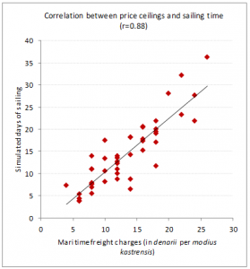
The primary focus of ORBIS in relation to DH approaches is mapping. There is however, a secondary approach which enhances the geospatial network and adds more information; the interrelation of datasets via algorithmic functions. Both these methods fit with the scholarly subject matter because they extract information in its original form and use it accordingly in ORBIS. In the Figure 1, the use of a dataset is illustrated in the correlation between price ceilings and sailing time. By pooling datasets together one can realistically visualise the network of the Roman World around 200 CE. The sea routes were established via documented ancient sources containing seal lanes. From these, other short-distances routes linking coastal sites and other medium-distance routes that were inspired by comparing historical data, serve to “fill the gaps” of the Roman Empire. For sea transport durations, verified historical sailing times for their specified sea routes were collected, reviewed and then incorporated into ORBIS.
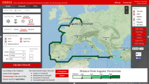
In Figure 2, the fastest route from Augusta Treverorum to Corinthus is illustrated. This journey is just over 7000 kilometres by sea and about 2700 kilometres by land. The duration for sea travel is approximately 55 days whereas by land it would take roughly 85 days. These estimations are only possible because of the DH methods and tools that, in ORBIS, have linked historical evidence and data sets to recreate the routes of transportation during the Roman Empire.
Comments
One response to “Analysis of ORBIS: The Stanford Geospatial Network Model of the Roman World”
Nice work!