This final project is the culmination of all the skills that were learnt during this Digital Humanities (DH) course. Little was it known that the introduction of the course material in the beginning of the semester foreshadowed the work that was to be completed for this project. The illustration of what the Shamokin region was like in the mid-1700s set the stage for the course as well as for our final project.
We learnt that the main objectives of the Moravian missionaries’ settlement in the United States were to minister the scattered German immigrants and to preach the Gospel to the Native American Indians. Much time, money and effort was expended in their efforts. What makes the Moravian existence so unique was that the missionaries carefully documented day-by-day accounts of occurrences that were in no way limited to religious matters. As a result we are provided with first hand accounts of happenings in the lives of missionaries throughout the 1700 and 1800s.
Brother Grube was one of these missionaries and we were lucky enough to gain access to a transcription of a journey he took in 1753. Based in Shamokin, Brother Grube travelled to locations along the Susquehanna River preaching the word of the Savior. The journey we examined took place from the 4th-10th of June 1753.
The main goal of the project was to gain knowledge on how missionaries built and maintained relationships with the native Indians and whether or not it is representative of successful Moravian missions in the Susquehanna region. Moreover, we wanted to gain a visual understanding of Brother Grube’s trip up the West Branch of the Susquehanna River. In order to achieve these objectives we decided upon two DH methods: Text Encoding Initiative (TEI) markup and ArcGIS.
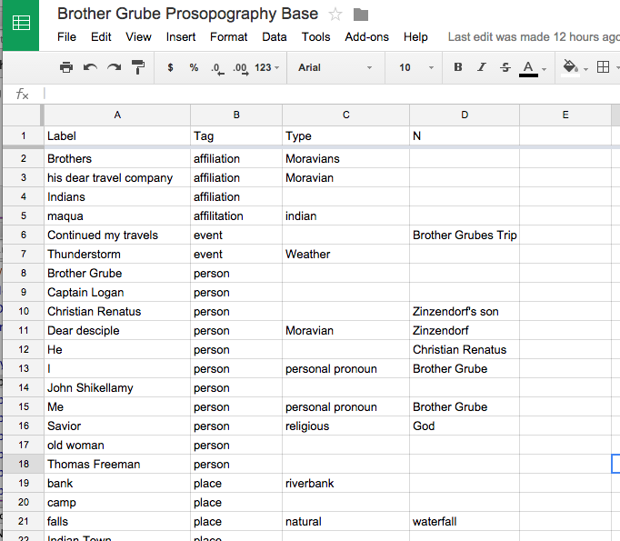
TEI is an international project used for the encoding of scholarly artifacts for further representation. In our case, through TEI markup we were able to build a prosopography database containing important people, locations and occurrences that would inform our visualisation via ArcGIS.
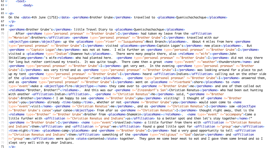
Anyone who has worked with TEI markup is aware of its ability to make the text extremely familiar; this of course depends on the thoroughness of the tagging. From being a novice at TEI markup not long ago, we progressed quite significantly and were able to meaningfully tag Brother Grube’s journal, even applying tags and nestings we had not previously used. As we tagged we became increasingly more in-depth and often re-tagged prior paragraphs. We noticed early on in the markup that Brother Grube, unlike Powell, consistently referred to himself in first person and that all occurrences were from his perspective. To account for this we used the following tag:
![]()
Since this document was much larger than those assigned from the Powell diary, we kept a record of specific tags used in special cases so that we didn’t have to sift through already marked-up text in order to find them. Following the completion of our markup there were several errors in need of correction. Due to the nature of the TEI markup program that we used (Oxygen), it was at times very difficult to locate the source of error.
After we were well versed in Brother Grube’s journey as a result of markup, we moved onto ArcGIS. This system is used for working with maps and geographic information. The many tools in ArcGIS, of which there are two many to name, enabled us to create a tailored map that told the story of Brother Grube’s journey. The first step was to identify the locations that were in our prosopography database on a map of today. We of course were impeded by the fact that towns and Indian villages that were thriving in the mid 1700s were nowhere near as prominent or even in existence today. The availability of georectified maps from the area of interest made this possible. We pinpointed important locations via the georectified map and transferred the location markers to a map of today. Onlookers can always question the accuracy of locations determined in this manner and for this reason we used approximations for sites that we did not have an exact location for. In one case, Brother Grube left his canoe approximately “10 miles this side of Ostonwakin”. We were able to estimate, using the measure tool, where this occurred and represent it graphically.
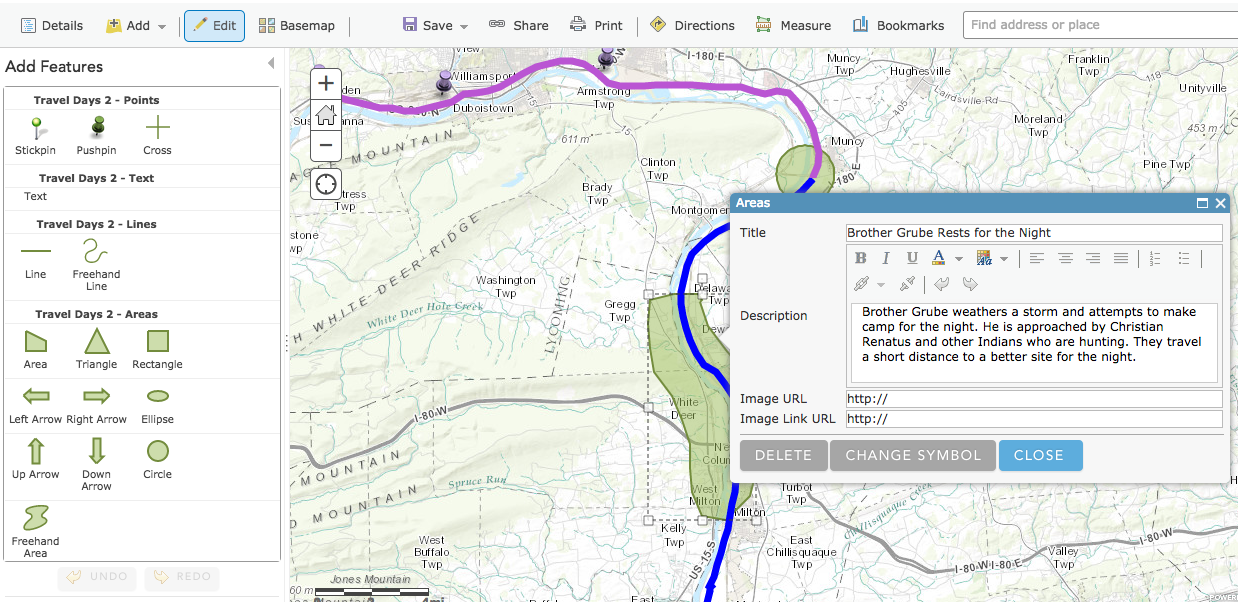
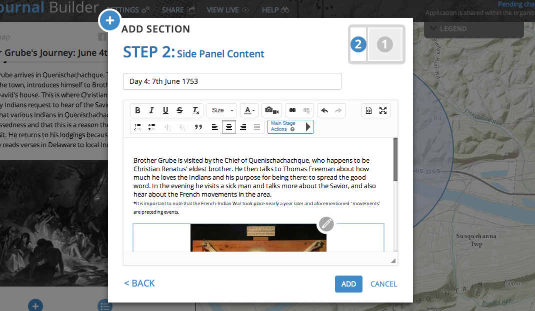
When we were satisfied with the tailored map of Brother Grube’s journey on ArcGIS, we published it using a web application called “Map Journal Builder”. This enabled us to develop our map and layers into story map. We could also add pictures and other configurations that made its viewing more aesthetically favourable.
By completing the two components of our project we were, for the most part, able to answer the questions we sought. We learnt that Moravian missionaries in the Shamokin area during this time built relationships by travelling to Indian villages to speak the word of the Savior. At times there was resistance, demonstrated by the Governor of Quenischachachque, but on the whole the majority of Indian population written about by Brother Grube in his diary, were receptive to his preaching. Unlike Powell, there wasn’t excessive mentioning of drunken Indians and it only cropped up in a conversation between Brother Grube and Brother Marx Kiefer when he returned to Shamokin. In the case of Brother Grube, the building of relationships with native Indians resulted in successes as missionary; he was welcomed where he travelled and was, more often than not, invited back.
In my first blog post for this class I discussed renowned DH projects that I automatically assumed used advanced tools and programming. What I realised was how far we have come in terms of understanding the methods and applying them. Ultimately, we were successful in creating our own DH project.